| DETAILING FEATURES |
| |
Symbols

|
Symbols and Notes
|
Profiles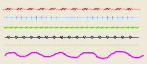
|
Profiles and Sketches
|
|
| |
|
 |
Facility to create detailed view of a portion of the map
|
|
Hundreds of scalable symbols. Customized for each state
|
|
Symbols that are always aligned and not aligned to North
|
|
Provision for Notes with modifiable size, style, color and orientation
|
|
Notes in different fonts, including local languages
|
|
Smooth Free Hand sketches to denote Streams and Roads
|
|
Multi-Line Profiles to represent Railways, Telephone/Electric Lines
|
|
Closed Polygons with hatching facility to represent buildings
|
|
Profiles with constraints like Parallel, Perpendicular, Orthogonal
|
|
Facility to create Arrows / Leads and Symbols using Profiles
|
|
Option to Copy, Modify, Move, Rotate, and Deletion the Details
|
|


